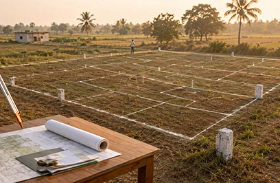
When buying land, checking the title deed and Encumbrance Certificate is important—but it is equally necessary to verify the property’s physical boundaries and measurements. This is where the Field Measurement Book (FMB) sketch becomes useful. It provides a graphical representation of a survey field, including its dimensions, boundary lines, subdivision details, and neighbouring survey numbers.
In Tamil Nadu, citizens can access FMB-related land records through the Tamil Nadu Government’s Land Records e-Services portal. The portal also states that copies of Field Measurement Sketches can be downloaded free of cost through its online services.
This blog explains the meaning, features, uses, and online process for obtaining an FMB sketch before purchasing or developing land.
FMB stands for Field Measurement Book. An FMB sketch is an official survey drawing that records the physical details of a land parcel. It is generally maintained by the Revenue Department and land survey authorities as part of the state’s land records.
The sketch may show:
In simple terms, an FMB sketch acts like a map of a particular survey field. It helps a buyer compare the dimensions stated in the sale agreement, parent documents, patta, and the actual land available on the ground.
However, an FMB sketch should not be treated as independent proof of ownership. Ownership is generally established through title documents, registered deeds, patta records, and other relevant records. The FMB primarily helps verify the physical identity, extent, and boundaries of the property.
A typical FMB sketch Tamilnadu record may contain several technical elements. Understanding these features can help buyers and property owners interpret the document more effectively.
The survey number identifies a larger land parcel recorded in the revenue records. If the original survey field has been divided, the subdivision number identifies the specific portion.
For Example: a survey number may be divided into portions such as 125/1A, 125/1B, or 125/1C. The FMB sketch should correspond to the survey and subdivision details mentioned in the patta and title documents.
The sketch records the length and direction of the field boundaries. These measurements are useful for checking whether the north, south, east, and west boundaries match the descriptions in the sale deed.
A difference between the document measurements and the physical measurements should be investigated before entering into a transaction.
An FMB sketch may show the survey numbers of adjoining properties. This can help identify whether the land is surrounded by private properties, government land, a road, a water channel, or another public feature.
This information is especially useful when a seller claims that a particular road or pathway forms part of the property boundary.
FMB sketches may contain technical lines used during the survey process. The field line generally represents the actual boundary of the surveyed land. Reference or grid lines help surveyors establish the position and alignment of the field.
These lines may not be easy for a first-time buyer to understand. A licensed surveyor can explain the measurements and confirm whether the sketch corresponds with the land on site.
Subdivision lines show how a larger survey field was divided into smaller parcels. When purchasing a plot from a larger layout, it is important to ensure that the plot’s subdivision details are properly reflected in the revenue records and approved layout documents.
An FMB sketch is an important part of land due diligence because it helps connect official records with the physical property.
A buyer can compare the sketch with the fencing, compound wall, access road, and other features visible at the site. This may help identify possible encroachments, boundary overlaps, or differences in the property’s actual extent.
The FMB provides a reference for surveyors when measuring the property. If the plot appears larger or smaller than the extent mentioned in the documents, the discrepancy should be clarified before registration.
A sale deed may refer to a subdivision number that is different from the one shown in the latest revenue record. Reviewing the FMB along with the patta and A-Register extract may help identify such inconsistencies.
FMB records may be referred to during boundary-related disputes. They can help authorities and surveyors understand the historical measurement and location of a survey field. However, the legal effect of the document depends on the facts of the case and the other available title records.
Those looking for FMB sketch for land in Tamil Nadu should examine it before paying an advance. It is particularly relevant when purchasing vacant land, agricultural land, converted land, or a plot formed from a larger survey field.
The Tamil Nadu Government provides online access to several land records, including Patta, Chitta, FMB, A-Register, TSLR, and related services. The information is dynamically updated, and citizens can use the portal to access records without necessarily visiting a Revenue Department office.
The following steps can be used to view FMB sketch online in Tamil Nadu:
The precise menu names and website interface may change from time to time. Therefore, users should rely on the official online FMB Sketch for Land in Tamil Nadu - rather than third-party websites claiming to issue government records.
The FMB sketch download in Tamil Nadu process is generally completed through the state’s online land records portal. The Tamil Nadu Government portal indicates that Field Measurement Sketch copies are available for download free of cost under the e-service.
Before beginning the download process, keep the following information ready:
After submitting the details, check whether the displayed sketch belongs to the correct village, survey number, and subdivision. Download the document only after verifying these particulars.
If the online record is unavailable, incomplete, or difficult to read, the owner may need to approach the concerned Taluk or Revenue office or use an authorised service centre. A licensed surveyor may also be required if the sketch needs to be compared with the physical boundaries at the site.
In some transactions, buyers may come across an Old FMB sketch in Tamil Nadu records. Older sketches can be useful, particularly when they show the original survey field before later subdivisions or changes in land classification.
However, an old sketch should not automatically be considered the latest or final record. The survey number may have been subdivided, re-surveyed, or updated in the revenue records. The buyer should compare the old sketch with:
For urban properties, the relevant land record may be a TSLR extract or TSLR sketch rather than a rural FMB record. The official portal separately lists FMB services for Rural/Natham village FMB sketch in Tamil Nadu and TSLR Sketch services for urban areas.
Obtaining a copy online is only the first step. Buyers should also verify whether the record matches the property being offered for sale.
Use this practical checklist:
For buyers exploring land FMB sketch in Tamilnadu records before purchasing a residential plot, this verification can reduce the risk of boundary disputes and documentation problems.
The FMB sketch is particularly relevant when evaluating plots for sale in Chennai, including plots located in developing suburbs and peripheral areas. A vacant plot may appear clearly demarcated on the ground, but its revenue boundaries may differ from the fencing or layout markings.
Before finalising a plot, compare the FMB or applicable urban survey record with the approved layout plan, sale deed, patta, road access, and site measurements. Buyers should also verify planning permission, land-use classification, access rights, and applicable approvals.
As a real estate developer and property brand, Omshakthy homes encourages buyers to approach land purchases with proper documentation and careful verification. An FMB sketch can be a valuable part of this process, but it should be reviewed along with all other legal and technical records.